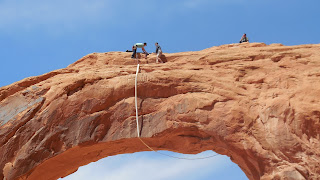
Roger posted a picture on Facebook last week of a hike that we did at Fisher Towers. A friend wrote back and asked if we were tired of "rocks" yet? After a chuckle, we both decided that these red rocks (actually huge boulders) are something that we could enjoy for a long time. That made us think about how lucky we are to have this opportunity to hike and have hiked in many areas of the Southwest and the Pacific Northwest. Hiking is something that we have truly come to enjoy and have learned a lot about the skills necessary to do it successfully.
Canyonlands National Park is one of over 390 parks in the National Park System. It is located about 20 miles from Moab. The park is divided into three sections: 1. Island In The Sky, 2. The Needles and 3. The Maze. The Colorado and Green Rivers divide the park into the three sections. The rivers converge at Confluence and form the Colorado River that flows into Lake Powell, and beyond. The Park was established in 1964 and remains largely rugged. Our trip on Saturday took us to the Island In The Sky Visitor Center for the beginning of a drive that took us throughout that section of the park. The Maze section is only reached by high clearance, four wheel drive vehicles and The Needles section is over 80 miles away from Moab. The Park covers 527 square miles.
Incredible vistas
Mesa Arch
The views through Mesa Arch are spectacular.
The rest of the week found us dodging rain and cold weather. However, we were able to work in a hike and a bike ride. After the rain disappeared on Wednesday, the sun came out in the afternoon and we were able to take Bear for a hike on Portal Overlook Trail. The hike started out along the Colorado River and we ascended rapidly over red rock.
Roger is removing clothing during the hike.
Bear is ready to go on up. The Colorado River flows south in this picture.
Rock Cairns mark the trail.
At the top of the climb
Moab from the top
Looking south from the top
The LaSal Mountains with lots of snow
Heading back down
On Thursday afternoon, we decided to ride out Potash Road (Utah Highway 279). Although we are in the land of premier mountain biking, there is also world class road cycling. We are true roadies at heart. This highway has several areas for rock climbers.
Heading out to the red rocks.
We parallel the Colorado River on the left of this picture with sheer rock faces on the right.
You can see the rock climber.
Friday was a hike to Bow Tie and Corona Arch. This turned out to be one of the most interesting hikes that we have done due to a "sport" called Pendulum Swinging. That means climbing an arch, jumping off of it and swinging. Corona Arch was the place where a man was killed doing this, two weeks ago. Imagine our surprise o find four jumpers waiting to try it (there is a sign warning people not to do it). The pictures below say it all.
Bow Tie Arch
Corona Arch
Years ago, a fixed wing airplane flew through this arch. You can barely see the people on top preparing for the jump.
A tree cairn marked the path to the arches. This hike involved lots of slippery rock and at points we had to use anchored cable lines to get on top of the rock.
Roger, Bear and I reaching the base of Corona Arch
There are four men preparing the lines for the jump.
It is hard for me to understand why people would choose to do this knowing that a man was killed at this very arch, two weeks ago.
The jumper proceeds to "pendulum swing" under the arch.
We have had a great second week in Moab. We are grateful for the chance to hike and bike in this beautiful area. Thank you for checking in with us. See you next week.


Beautiful pictures. What a great place to be this spring.
ReplyDelete